Query-response geocast for vehicular crowd sensing

November 13, 2015 in Journals, Publications, TUB, year 4 by Ulrich Schwesinger

Timpner, Julian and Wolf, Lars

Ad Hoc Networks
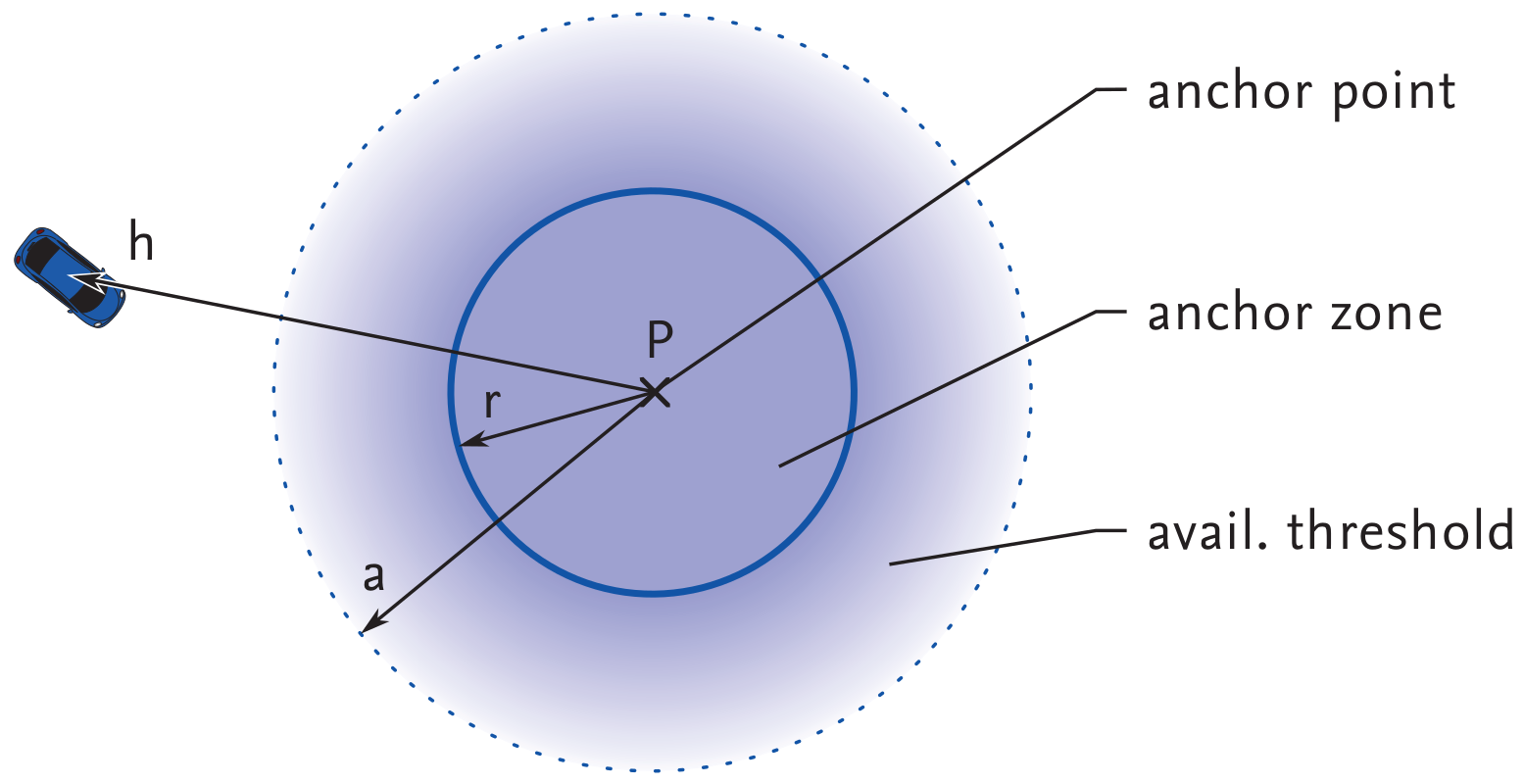
Modern vehicles are essentially mobile sensor platforms collecting a vast amount of information, which can be shared in vehicular ad hoc networks. A prime example of a resulting vehicular crowd sensing application might be the search for a parking spot in a specific geographic area. The interested vehicle sends a corresponding query into the destination area—a technique known as geocast. As the query originator, however, is likely to have moved relatively far away from the location from where the query was started by the time the response arrives, an efficient routing approach towards the originator is required. In this paper, we extend the Breadcrumb Geocast Routing (BGR), a georouting protocol for vehicular networks that is able to close this functional gap. We introduce several performance improvements. In particular, we focus on further reducing both the delivery delay and network overhead and on the dynamic adaption of breadcrumbs to the street layout, node density and other scenario-specific parameters. Extensive simulations in four different urban scenarios show a significant improvement on BGR, especially in terms of delivery delay, which can be reduced by an average of 24%.
Breadcrumb Geocast Routing Version 2 (BGR2) thus not only avoids up to 93% of the traffic overhead of Epidemic, but increases the delivery rate of the underlying georouting protocol significantly from about 48% to almost 100% even in difficult scenarios. In sum, it is shown that BGR2 and breadcrumbs in general are a feasible and efficient approach for the routing of query responses to moving nodes via geocast, enabling a variety of vehicular crowd sensing applications.


@article{Timpner:AdHoc:2015,
abstract = {},
author = {Timpner, Julian and Wolf, Lars},
doi = {10.1016/j.adhoc.2015.06.003},
issn = {15708705},
journal = {Ad Hoc Networks},
keywords = {Crowd sensing,Geocast,Query response,Routing,V2V,VANET},
month = {jun},
number = {Special Issue on Vehicular Crowd Sensing},
title = {{Query-response geocast for vehicular crowd sensing}},
url = {https://www.sciencedirect.com/science/article/pii/S1570870515001286},
year = {2015}
}
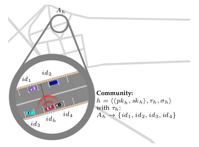
Trustworthy Parking Communities: Helping Your Neighbor to Find a Space

November 13, 2015 in Journals, Publications, TUB, year 4 by Ulrich Schwesinger

Timpner, Julian and Schürmann, Dominik and Wolf, Lars

IEEE Transactions on Dependable and Secure Computing

Cooperation between vehicles facilitates traffic management, road safety and infotainment applications. Cooperation, however, requires trust in the validity of the received information. In this paper, we tackle the challenge of securely exchanging parking spot availability information. Trust is crucial in order to support the decision of
whether the querying vehicle should rely on the received information about free parking spots close to its destination and thus ignore other potentially free spots on the way. Therefore, we propose Parking Communities, which provide a distributed and dynamic means to establish trusted groups of vehicles helping each other to securely find parking in their respective community area. Our approach is based on high-performance state-of-the-art encryption and signature algorithms as well as a well-understood mathematical trust rating model. This approach allows end-to-end encrypted request-response communications in combination with geocast and can be used as an overlay to existing vehicular networking technologies. We provide a comprehensive comparison with other security architectures and simulation results showing the feasibility of our approach.

@article{Timpner2014b,
author = {Timpner, Julian and Sch\"{u}rmann, Dominik and Wolf, Lars},
doi = {https://dx.doi.org/10.1109/TDSC.2015.2427838},
journal = {IEEE Transactions on Dependable and Secure Computing},
publisher = {IEEE Comput. Soc},
title = {{Trustworthy Parking Communities: Helping Your Neighbor to Find a Space}},
year = {2015}
}
Summary maps for lifelong visual localization

November 13, 2015 in ETHZ-ASL, Journals, Publications, VW, year 4 by Ulrich Schwesinger

Peter Muehlfellner, Mathias Buerki, Michael Bosse, Wojciech Derendarz, Roland Philippsen and Paul Furgale

Journal of Field Robotics

Robots that use vision for localization need to handle environments which are subject to
seasonal and structural change, and operate under changing lighting and weather conditions.
We present a framework for lifelong localization and mapping designed to provide
robust and metrically accurate online localization in these kinds of changing environments.
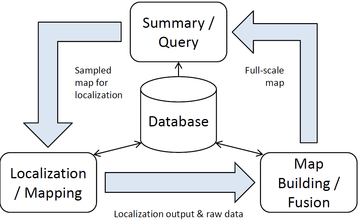
Our system iterates between offline map building, map summary, and online localization.
The offline mapping fuses data from multiple visually varied datasets, thus dealing with
changing environments by incorporating new information. Before passing this data to the
online localization system, the map is summarized, selecting only the landmarks that are
deemed useful for localization. This Summary Map enables online localization that is accurate
and robust to the variation of visual information in natural environments while still
being computationally efficient.

We present a number of summary policies for selecting useful features for localization from
the multi-session map and explore the tradeoff between localization performance and computational
complexity. The system is evaluated on 77 recordings, with a total length of 30
kilometers, collected outdoors over sixteen months. These datasets cover all seasons, various
times of day, and changing weather such as sunshine, rain, fog, and snow. We show that it
is possible to build consistent maps that span data collected over an entire year, and cover
day-to-night transitions. Simple statistics computed on landmark observations are enough
to produce a Summary Map that enables robust and accurate localization over a wide range
of seasonal, lighting, and weather conditions.

@article{muhlfellner2015summary,
title={Summary maps for lifelong visual localization},
author={M{\"u}hlfellner, Peter and B{\"u}rki, Mathias and Bosse, Mike and Derendarz, Wojciech and Philippsen, Roland and Furgale, Paul},
journal={Journal of Field Robotics},
year={2015},
publisher={John Wiley \& Sons}
}

Introspective Classification for Robot Perception

November 13, 2015 in Journals, Oxford-MRG, Publications, year 4 by Ulrich Schwesinger

H. Grimmett, R. Triebel, R. Paul, and I. Posner

International Journal of Robotics Research (IJRR)

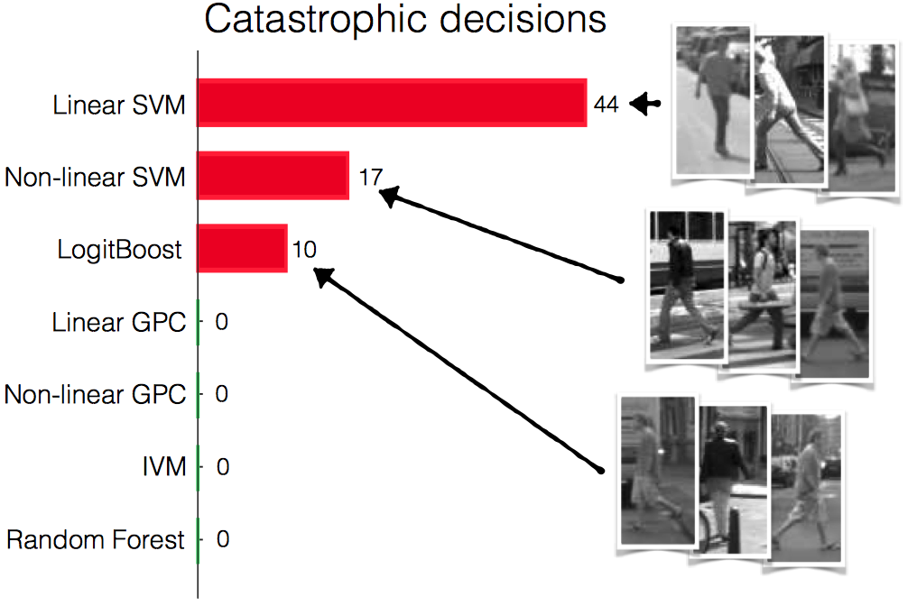
In robotics, the use of a classification framework which produces scores with inappropriate confidences will ultimately lead to the robot making dangerous decisions. In order to select a framework which will make the best decisions, we should pay careful attention to the ways in which it generates scores. Precision and recall have been widely adopted as canonical metrics to quantify the performance of learning algorithms, but for robotics applications involving mission-critical decision making, good performance in relation to these metrics is insufficient. We introduce and motivate the importance of a classifier’s introspective capacity: the ability to associate an appropriate assessment of confidence with any test case. We propose that a key ingredient for introspection is a framework’s potential to increase its uncertainty with the distance between a test datum its training data.
We compare the introspective capacities of a number of commonly used classification frameworks in both classification and detection tasks, and show that better introspection leads to improved decision-making in the context of tasks such as autonomous driving or semantic map generation.

@article{GrimmettIJRR2015,
Author = {Grimmett, Hugo and Triebel, Rudolph and Paul, Rohan and Posner, Ingmar},
Journal = {International Journal of Robotics Research (IJRR)},
Pdf = {https://www.robots.ox.ac.uk/~mobile/Papers/2015IJRR_Grimmett.pdf},
Title = {{I}ntrospective {C}lassification for {R}obot {P}erception},
Year = {2015}}

Vision-Only Fully Automated Driving in Dynamic Mixed-Traffic Scenarios

October 6, 2015 in ETHZ-ASL, Journals, Publications, year 4 by Ulrich Schwesinger

U. Schwesinger, P. Versari, A. Broggi and R. Siegwart

it – Information Technology, 2015

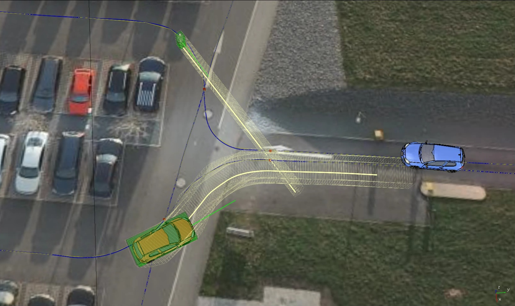
In this work an overview of the motion planning and dynamic perception framework within the V-Charge project is presented. This framework enables the V-Charge car to autonomously navigate in dynamic mixed-traffic scenarios. Other traffic participants are detected, classified and tracked from a combination of stereo and wide-angle monocular cameras. Predictions of their future movements are generated utilizing infrastructure information. Safe motion plans are acquired with a system-compliant sampling-based local motion planner. We show the navigation performance of this vision-only autonomous vehicle in both simulation and real-world experiments.

@article{SchwesingerVBS15,
author = {Ulrich Schwesinger and
Pietro Versari and
Alberto Broggi and
Roland Siegwart},
title = {Vision-only fully automated driving in dynamic mixed-traffic scenarios},
journal = {it - Information Technology},
volume = {57},
number = {4},
pages = {231--242},
year = {2015},
url = {https://www.degruyter.com/view/j/itit.2015.57.issue-4/itit-2015-0005/itit-2015-0005.xml},
}

by admin

Lighting-Invariant Adaptive Route Following Using ICP

January 21, 2015 in Journals, Publications, year 4 by admin

Philipp Krüsi, Bastian Bücheler, Francois Pomerleau, Ulrich Schwesinger, Roland Siegwart, and Paul Furgale

Journal of Field Robotics, 2014

Topological/metric route following, also called teach and repeat (T&R), enables long-range autonomous navigation even without globally consistent localization. In the teach pass, the robot is driven manually and builds up a topological/metric map of the environment: a graph of metric submaps connected by relative transformations. For repeating the route autonomously, the map only needs to be locally consistent; errors on the global level due to localization drift are irrelevant. This renders T&R ideal for applications where a global positioning system may not be available, such as navigation through street canyons or forests in search and rescue, reconnaissance in underground structures, surveillance, or planetary exploration.

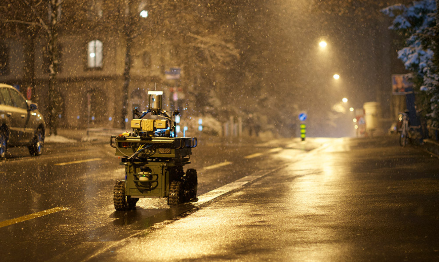
We present a T&R system based on iterative closest point matching (ICP) using data from a spinning three-dimensional (3D) laser scanner. Our algorithm is highly accurate, robust to dynamic scenes and extreme changes in the environment, and independent of ambient lighting. It enables autonomous navigation along a taught path in both structured and unstructured environments, including highly 3D terrain. Furthermore, our system is able to detect obstacles and avoid them by adapting its path using a local motion planner. It enables autonomous route following in non-static environments, which is not possible with classical T&R systems.

We demonstrate our algorithm’s performance in two long-range driving experiments, one in a highly dynamic urban environment, the other in unstructured, rough, 3D terrain. In these experiments our robot autonomously drove a distance of over 22 kilometers in both day and night. We analyze the localization accuracy of our system and show that it is highly precise. Moreover, we compare our ICP-based method to a state-of-the-art stereo-vision-based technique and show that our approach has a greatly increased robustness to path deviations and is less dependent on environmental conditions.


@article{kruesi_jfr14,
note = { Accepted for publication on March 31, 2014. },
journal = { Journal of Field Robotics },
year = { 2014 },
title = { Lighting-Invariant Adaptive Route Following Using ICP },
author = { Philipp Kr\"{u}si and Bastian B\"{u}cheler and Fran\c{c}ois Pomerleau and Ulrich Schwesinger and Roland Siegwart and Paul Furgale },
}

by admin

Associating Uncertainty with Three-Dimensional Poses for use in Estimation Problems

July 17, 2014 in ETHZ-ASL, Journals, Publications, year 4 by admin

Barfoot, Furgale

Robotics, IEEE Transactions on, 30(3), pp. 679-693

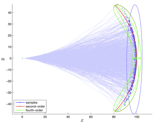
In this paper, we provide specific and practical approaches to associate uncertainty with 4 ?? 4 transformation matrices, which is a common representation for pose variables in 3-D space. We show constraint-sensitive means of perturbing transformation matrices using their associated exponential-map generators and demonstrate these tools on three simple-yet-important estimation problems: 1) propagating uncertainty through a compound pose change, 2) fusing multiple measurements of a pose(e.g., for use in pose-graph relaxation), and 3) propagating uncertainty on poses (and landmarks) through a nonlinear camera model. The contribution of the paper is the presentation of the theoretical tools, which can be applied in the analysis of many problems involving 3-D pose and point variables.


@article{barfoot_tro14,
year = { 2014 },
title = { Associating Uncertainty with Three-Dimensional Poses for
use in Estimation Problems },
codeurl = { https://asrl.utias.utoronto.ca/code/barfoot_tro14.zip },
journal = { Robotics, IEEE Transactions on },
author = { Barfoot and Furgale },
pages = { 679-693 },
number = { 3 },
volume = { 30 },
month = { jun },
doi = { 10.1109/TRO.2014.2298059 },
}

by admin

Design and Evaluation of Charging Station Scheduling Strategies for Electric Vehicles

January 21, 2014 in Journals, Publications, TUB, year 3 by admin

Julian Timpner and Lars C. Wolf

IEEE Transactions on Intelligent Transportation Systems (Journal)

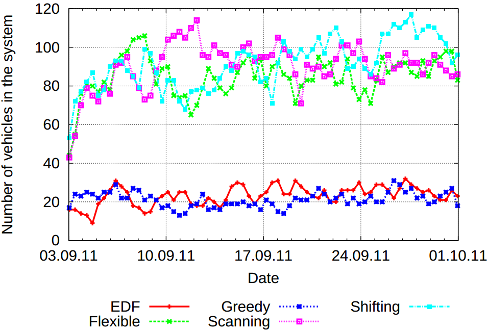
Electric vehicles (EVs) still have relatively long and frequent charging cycles. Moreover, charging resources are typically limited and must therefore be used efficiently. The V-Charge project has the vision to provide a solution by combining autonomous valet parking with e-mobility, introducing improved parking and charging comfort. V-Charge proposes a solution for charging autonomous EVs in parking places and efficiently using scarce charging resources, thus simplifying the life of the customer and increasing the feasibility of EVs. For the management of parking lots and charging resources, V-Charge provides a server back end and a communication infrastructure. In this paper, we present our design of scheduling concepts for a coordinated charging strategy that is implemented by this back end. Through intensive simulations, we show that the V-Charge server is able to efficiently handle realistic parking volume and performs well in fulfilling customer requirements, e.g., energy demand for the next driving tasks. Moreover, we evaluate the suitability of various scheduling strategies in different usage scenarios. For the simulation setup, real-world parking statistics obtained from Hamburg Airport and the City of Braunschweig, Germany, are used.


@article{Timpner:TITS:2013,
author = {Timpner, Julian and Wolf, Lars},
doi = {10.1109/TITS.2013.2283805},
journal = {IEEE Transactions on Intelligent Transportation Systems},
publisher = {IEEE},
title = {{Design and Evaluation of Charging Station Scheduling Strategies for Electric Vehicles}},
year = {2013},
month=nov,
volume=PP,
number=99,
issn={1524-9050},
URL={https://ieeexplore.ieee.org/xpl/articleDetails.jsp?arnumber=6651804},
}

by admin

Estimation of Vehicular Connectivity in Autonomous Parking Scenarios

January 21, 2014 in Journals, Publications, TUB, year 3 by admin

Tobias Pögel, Julian Timpner, Stephan Rottmann and Lars C. Wolf

PIK – Praxis der Informationsverarbeitung und Kommunikation (Journal)

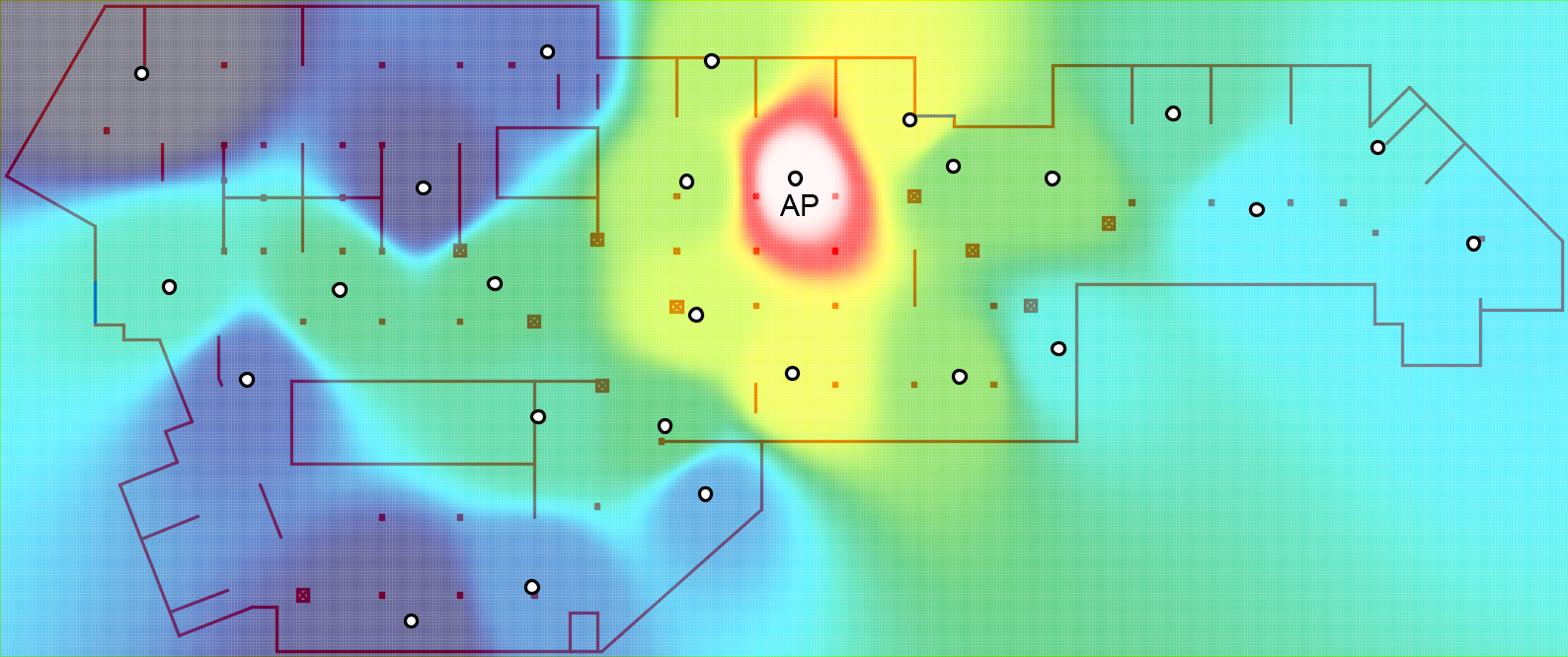
In this paper different parking scenarios for autonomous vehicles are considered. For control and monitoring purposes reliable Wi–Fi-based communication between the vehicles and a back-end is needed. It must be ensured that potential QoS requirements of different applications are met and that vehicles do not hit so-called “white spots” without any network connectivity. The network properties are represented and estimated by a Connectivity Map. For this purpose, network and measurement data are continuously collected so that other vehicles can be provided with the newly gained knowledge, which allows the planning of the proposed scenarios. This paper shows potential QoS requirements and discusses the necessary steps for the realization of such a Connectivity Map.
In addition to the automated continuous collection of relevant network parameters as a byproduct of vehicular communications, the mapping of the scenarios in terms of floor plans with additional meta-information as well as the representation of connectivity properties are shown.
We outline our vision for using the developed Connectivity Map for advanced parking management decisions.


@ARTICLE{Poegel:PIK:2013,
AUTHOR={Tobias {P{\"o}gel} and Julian Timpner and Stephan Rottmann and Lars C Wolf},
TITLE="Estimation of Vehicular Connectivity in Autonomous Parking Scenarios",
JOURNAL="PIK - Praxis der Informationsverarbeitung und Kommunikation",
PAGES={243-248},
VOLUME=36,
NUMBER=4,
DAYS=1,
MONTH=dec,
YEAR=2013,
URL={https://www.degruyter.com/view/j/piko-2013-36-issue-4/pik-2013-0026/pik-2013-0026.xml},
}

by admin

Reciprocal Collision Avoidance With Motion Continuity Constraints

September 20, 2013 in ETHZ-ASL, Journals, Publications, year 3 by admin

Martin Rufli, Javier Alonso-Mora, Roland Siegwart

IEEE Transactions on Robotics (T-RO)

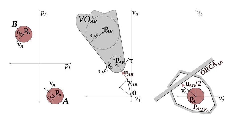
This paper addresses decentralized motion planning among a homogeneous set of feedback-controlled, decision-making agents. It introduces the continuous control obstacle (C^n-CO), which describes the set of C^n-continuous control sequences (and thus trajectories) that lead to a collision between interacting agents. By selecting a feasible trajectory from C^n-CO’s complement, a collision-free motion is obtained. The approach represents an extension to the reciprocal velocity obstacle (RVO, ORCA) collision-avoidance methods so that trajectory segments verify C^n continuity rather than piecewise linearity. This allows the large class of robots capable of tracking C^n-continuous trajectories to employ it for partial motion planning directly—rather than as a mere tool for collision checking. This paper further establishes that both the original velocity obstacle method and several of its recently developed reciprocal extensions (which treat specific robot physiologies only) correspond to particular instances of C^n-CO. In addition to the described extension in trajectory continuity, C^n-CO thus represents a unification of existing RVO theory. Finally, the presented method is validated in simulation—and a parameter study reveals under which environmental and control conditions C^n-CO with n>0 admits significantly improved navigation performance compared with inflated approaches based on ORCA.


@article{rufli_TRO13
author = {M Rufli and J Alonso-Mora and R Siegwart},
title = {Reciprocal Collision Avoidance With Motion Continuity Constraints},
journal = {IEEE Transactions on Robotics},
volume = {29},
number = {4},
year = {2013},
pages = {1-14}
}